C-MAP launches new features & improvements to MAX N+ charts
C-MAP, a leader in digital marine cartography and cloud-based mapping, has announced the release of a new version of their MAX N+ charts featuring a variety of updates and improvements. Enhancements to the charts include new port plans, as well as additional detail to existing ports, High Resolution Bathymetry (HRB), Genesis Layer overlay and more detailed information at all zoom levels.
Updated detailed port plans
New and updated port and marina plans now offer an unprecedented level of detail, allowing boaters to approach any harbour and inlet with confidence. The perfect conclusion to a long voyage, sailing adventure or exciting day fishing.


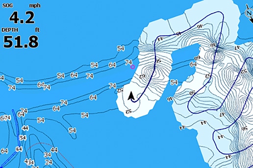
High Resolution Bathymetry (HRB)
New High Resolution Bathymetry (HRB) enhances C-MAP MAX-N+ charts with the highest resolution depth contour detail available. The HRB Layer offers extra-contours of underwater pinnacles, ledges and canyons to show best in class detail, helping you find the best fishing spots as well as navigate safely. This new level of detail combined with the custom depth shading, which is available in all Navico (Lowrance, Simrad and B&G) chartplotters, is especially helpful to fisherman who are looking to highlight the areas where fish gravitate.


Genesis Layer
The new Genesis Layer feature allows anglers to takeadvantage of the powerof community. This update sees C-MAP MAX-N+ charts come pre-programmed with C-MAP Genesis Social Map data for both coastal and fresh water. When used with Genesis Live, it also allows you to discover new fishing spots directly on your Lowrance plotter. Create your own map for free, in real-time and turn on an overlay on your C-MAP MAX-N+ chart.


The new improvements to C-MAP MAX-N+ charts also allow all information to be displayed and viewable, whatever the zoom level. Available now, the improvements come with new chart purchases or as a download from gofreemarine.com