Garmin launches new products for 2022
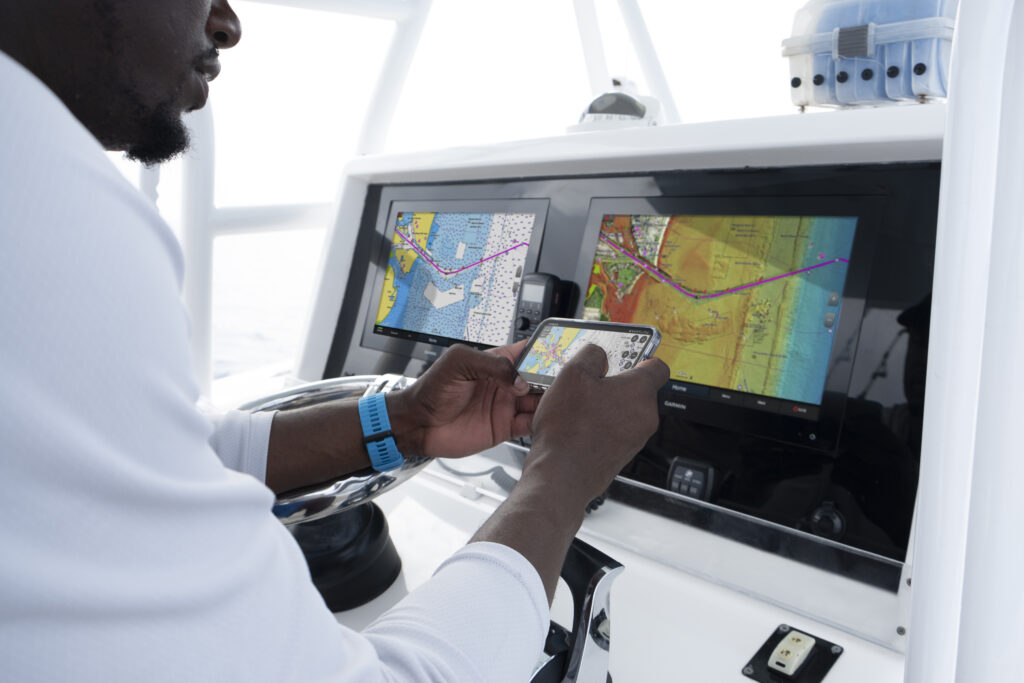
The new cartography products for all-in-one coastal and inland mapping from marine electronics manufacturer, Garmin, feature access to daily chart updates and new Auto Guidance+ technology.
According to the manufacturer, the Garmin Navionics+ & Garmin Navionics Vision+ offer an all-in-one mapping solution, include updated vibrant colours and ‘detail-rich’ mapping, plus daily chart updates (of up to 5,000 updates to chart content every day).
Garmin says: ‘Garmin Navionics+ and Garmin Navionics Vision+ introduce an improved look and feel – with vivid colour palettes and greater detail of coastal and inland features – to deliver a new, on-screen cartography presentation for more intuitive navigation on lake or sea. This new interface displays charts in striking detail with a crystal-clear look at the depths below the boat, as well surrounding structure and navigational aids above the waterline.’
The new Garmin Navionics+ & Garmin Navionics Vision+ cartography also include Auto Guidance+ technology, which now has faster route calculations and improved routing detail. Auto Guidance+ considers a variety of factors, from depths to hazards to channels, then creates a suggested route for mariners to follow to their desired destination.
“Garmin Navionics+ and Garmin Navionics Vision+ offer our best and most feature-rich marine cartography experience to date – a true game-changer for boaters and anglers,” says Dan Bartel, Garmin vice president of global consumer sales. “Now, with new coverage regions, mariners have the freedom to confidently explore inshore and offshore waters with a full suite of mapping content and advanced features. Plus, with access to daily chart updates, mariners can stay informed about the latest changes to their maps and charts and benefit immediately from new cartography releases.”
The new Garmin cartography offers all-new chart presentation, daily chart updates and advanced autorouting capabilities. It also features colour-shaded target depth ranges, up to 0.5m depth contours, shallow water shading and exclusive access to ActiveCaptain community content for valuable insight on points of interest (POI), recommendations and advice from fellow boaters.
Daily chart updates combine millions of contributions from private and public surveyors, crowd-sourced data and more, delivering the freshest, most up-to-date content each time mariners leave shore. With coverage of more than 42,000 lakes worldwide, daily updates allow for immediate access to new chart data and lake content as it is released. A one-year subscription is included with the purchase of Garmin Navionics+ or Garmin Navionics Vision+ and offer a quick-and-easy way to sync a mobile device to Garmin chartplotters for unlimited daily updates via the ActiveCaptain® smart device app.
New Garmin cartography also includes Auto Guidance+ technology with faster route calculations and improved routing detail. After selecting departure and arrival points, Auto Guidance+ considers a variety of factors – overhead clearance, chart data, popular routes and desired depth – then creates a suggested route for mariners to follow to their destination.
For more advanced features, boaters and anglers can upgrade to premium Garmin Navionics Vision+. Premium Garmin cartography includes all the standard features found in Garmin Navionics+, with the addition of relief shading, unique 3D views, high-resolution satellite imagery, aerial photography and more.
Garmin Navionics+ and premium Garmin Navionics Vision+ can be purchased via download or microSD card for compatible Garmin chartplotters.