FarSounder enhances SonaSoft seafloor mapping
FarSounder has announced new enhancements to its SonaSoft Software featuring an expansion of its local history mapping (LHM) application.
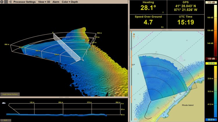
All models of the Argos Forward Looking Sonar system have the ability to recall user-collected data – limited only by the amount of available hard drive space. LHM is an advanced, innovative software feature that allows users to generate a map of the seafloor as they navigate.
Also available later this year will be the ability to view LHM data in FarSounder’s 3D Omni view as well as its chart view on the user interface. A single pass of the Argos sonar can map an expansive swath of the seafloor in real time, says the company. The LHM application displays this data as a 3D map of the seafloor, which is updated with every ping. Upon returning to a location where LHM data has been collected, the user will see the bottom history in both views along with the real-time data.
“The key purpose of an Argos sonar has always been improving situational awareness by detecting the seafloor depth and navigational hazards, in real-time, in front of the vessel,” says Heath Henley, Ph.D., senior application engineer at FarSounder.
“However, the enhancements of unlimited LHM storage and the display of this data in both the 3D omni view and the chart view allows the user to leverage their previously recorded data to further improve their knowledge of their environment and make well-informed navigation decisions.”
The more information available about the environment below the surface, the easier it is to make sound navigation decisions. FarSounder says the combining history and real-time data adds unprecedented value in keeping the vessel and its passengers safe.